Similar Structures Around The World

Fingals-Cave-on-the-Island-of-Staffa-compressor

From eerie crater lakes to travertine terraces, the earth has a knack for bringing out surreal landscapes. Some of the most amazing and strangest features are formed via volcanic processes. 

As basaltic lava emerges on the floor of the earth and cools down, fascinating geometric features form. Incredible hexagonal basalt rock columns will often form giant cliffs that can get as high as possible.

These attractive features can be found all over the world. It is so intriguing to see beautiful features formed after lava flow even after so many years. 

Basaltic lava is responsible for these formations; it usually is hotter and moves faster. The entire process is known as columnar jointing. This article investigates insights on some of these remarkable features and the stories surrounding them. 

Fingals-Cave-on-the-Island-of-Staffa-compressor

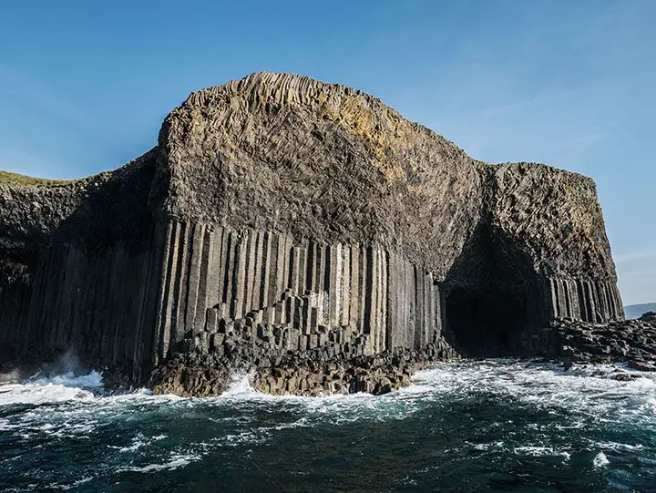
1. Fingals Cave, Staffa Flow

Found off the coast of Scotland, Fingals cave is just across the sea from the Giants Causeway and can be seen on a clear day. The Isle of Staffa was formed from the same lava action that created the Giants Causeways around 50 million years ago.

The name ‘Fingal’ originally comes from an Irish myth, where the hero Fionn MacCumhaill’s or Finn McCool (shortened to ‘Fingal’, meaning ‘white stranger’) and his faithful warriors migrated into Scotland from Ireland.

The legend is that Fionn built the Giant’s Causeway, which is identical to Fingal’s Cave, after a challenge to fight a Scottish Giant Bennandoner. He soon became famous across Scotland, making his name the obvious choice.

2. Fingals Beach Headland, NSW Australia

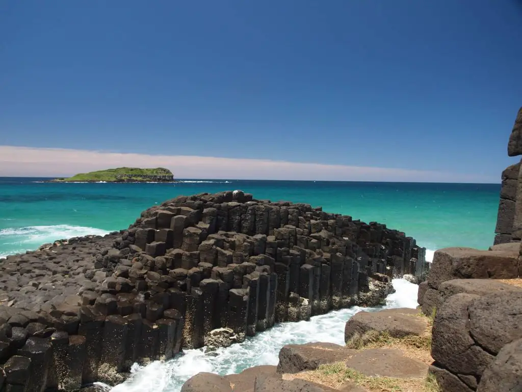
Fingal’s Beach Headland is a magnificent geological formation located on the north coast New South Wales

At Fingal’s Beach Headland, nature has crafted its own masterpiece, similar to the Giants Causeway. The headland showcases stunning hexagonal basalt columns, just like its more famous relative. These extraordinary columns result from volcanic activity millions of years ago, where rapidly cooling lava formed characteristic hexagonal shapes.

While not as extensive as the Giant’s Causeway, Fingal’s Beach Headland still boasts an impressive display of these geological wonders, creating a breathtaking sight for visitors. The area surrounding the headland is adorned with dramatic coastal cliffs, providing a picturesque backdrop to the incredible rock formations.

Both locations are steeped in folklore and legends, with the Giant’s Causeway being associated with mythical stories of giants, and Fingal’s Beach Headland also having its own local tales that add to the allure of the place

Thanks to Brent from Brownsigns.net.au for letting us know about this amazing place.

Hexagon-Pool-Israel-@Shutterstock-compressor

3. The Hexagon Pool, Israel

Also known as Breichat HaMeshushim, this hexagon pool in Israel is enclosed by a conserved forest found at the bottom part of a grand canyon. 

The stunning Hexagon Pool is a sought-after destination in the northern part of Israel for swimmers and hikers. The formation of this pool was quite phenomenal as it was formed after water flowed over the igneous rock that had cooled down.

David Brooks once described the hike via the forest to the pool as “a little treacherous at times,” but the scenery is quite captivating and worth the effort. The scene is merely magical, and every photographer would die to capture these fascinating views.

Svartifoss-Waterfall-in-Iceland-@Shutterstock

4. Svartifoss Waterfall

The Vatnajokull National park in Iceland, also known as Black Fall, encompasses an astounding waterfall on beautiful dark columns. Iceland is known to feature numerous basalt columns because of the multiple igneous formations and several volcanoes.

They are all captivating and spellbinding with every new pillar you come across. However, it is not advisable to jump to the bottom of the fall, unlike in Hexagon Pool. At the bottom of the fall are sharp rocks that are as a result of the fallen columns making it very risky. 

Photographers will also capture magical shots here as it is one of the ideal places for photography in Iceland.

The-devils-Postpile-in-California-@Shutterstock


5. Devils Postpile California

National park service categorizes this feature in California as “one of the world’s finest examples of columnar basalt.” The national monument goes reaches to a height of 60 feet and has an unusual symmetry. 

This beguiling feature appeared as a result of impeded lava vent. The vent led to the creation of a vast lake, which later cooled down and resulted in the formation of the hexagonal columns visited by numerous tourists all year round.

Takachiho-Gorge-Japan-@Shutterstock


6. Takachiho Gorge Japan

The enchanting green gorge in Japan is unique since the columns rise to more than 300 feet above the ground and also a bewitching hue. 

Plants have grown down the columns found in this place because water runs through this region all the time. A riveting waterfall (Manai waterfall) continuously erodes the rock, and tourists can experience this fantastic view from the small lake below the columns.

Cape-Stolbchaty-Russia-@Shutterstock


7. Cape Stolbchaty Russia

 Located on Kunashir Island, this basalt colum or pillars can be seen on the Kuril Islands of Russia.

The columns can be seen while you are at the Sea of Ohotsk just along its coastline. Cape Stolbchaty columns are estimated to be have existed for 50 million years, and are a UNESCO world heritage site like the Causeway.

Tourists can observe a magnificent geometric site as they do tours along the top of these columns.

Basalt-Cliffs-South-Korea-@Shutterstock

8. Basalt Cliffs South Korea

Jeju Island is a volcanic Island found in South Korea. Massive basalt pillars can be discovered on this Island. Jusangjeolli cliffs provide visitors with spectacular views of the columns as they dropdown. 

They were formed more than 100,000 years back because of volcanic activities. Jusangjeolli cliffs are the most beautiful and mysterious cliffs in South Korea, according to The Jeju Weekly.

Los-Prismas-Basalticos-Mexico-@ShutterstockLos-Prismas-Basalticos-Mexico-@Shutterstock

9. Los Prismas Basalticos Mexico

Los Prismas Basalticos, located in Hildago, Mexico, can be observed in a gorge, and they are popular because of the delightful waterfall that traverses over them. 

Standing nearly 100 feet above the water below, the rocks have been shaped to appear like lumpy steps by the ever-flowing stream. 

Tourists can experience immersing experience by climbing on the rocks and cooling off at the waterfall.

Los-Organos-Canary-Island-Spain-@Shutterstock

10. Los Organos Spain

Impossibly daunting and immense, these giant columns are named “pipes of the musical instrument.” It is apparent why these phenomenal columns were named that way. 

The rocks rise to 2,000 feet, and they can be observed on the Canary Islands. Los Organos is genuinely a geographical prodigy worth seeing. 

Genh-Da-Dia-Phu-Pen-Vietnam-@Shutterstock

11. Ghenh Da Dia Vietnam

These columns may appear tinier than the others on this list, but their spectacular formation and quick view make them among the best columns worth a visit. 

Found in Vietnam, Ghen Da Dia column rocks form a star design, unlike the other columns which form hexagons.

Zlaty-vrch,-Czech-republic-@Shutterstock

12. Zlaty Vrch Czech Republic

Located near the southeastern border of the Czech Republic with Germany, these beautiful columns provide visitors with picturesque views. A range of mountains orchestrates this region with magnificent columns formed years back.

 This range of mountains consists of sandstone sedimentary rocks forming a crystalline basement. During this formation, lava broke through the sandstone and solidified to create basalt columns leading to the creation of this great feature in the Czech Republic.

Reynisfjara Beach, Vik Village, Iceland (Sudurland) @Shutterstock

13. Reynisfjara Beach, Vik Village, Iceland

These gorgeous cliffs can be visibly seen below the Reynisfjall Mountain. These columns can be found at the rear end of the mysterious black sand beach. Columns here rise to 66 meters above the waters. Reynisdrangar acts as a trademark for Vik in Myrdal, which is a village in Iceland.

 It is believed that two trolls had been pulling a ship to the beach, but they were not successful. The elves were ambushed by sunlight in the morning, and they now turned into stone according to myths about trolls getting caught up by sunlight at dawn

Penghu-Taiwan-@Shutterstock

14. Penghu, Taiwan

A basalt rock formation that resembles a city wall and also looking like monoliths on land can be observed on the Taiwan Strait. The wall is 10 meters high and 200 meters long in the water. Columns here resemble numerous pillars that have been put together.

 The basaltic features are a tremendous phenomenal since most of these features are seen above the water, but this is underwater. Visit this great feature in Taiwan to enjoy the great sensation.

Rocha dos Bordoes in Flores Island, Azores, Portugla

15. Flores Island, Portugal

Flores Island is found in the Western group of Azores. If there is a place you should visit, is this enchanting place. This Island in Portugal is characterized by an extremely rugged and heavily indented coastline. Flores is known to have magnificent waterfalls, streams, and striking columns.

 The Island is tiny, and you can discover it in a short period. Explore the beautiful landscapes of this fascinating Island as you walk at the top of the basalt pillars. 

Litlanesfoss-Fljotsdalur-valley-in-East-Iceland-@Shutterstock

16. Litlanesfoss, Fljotsdalur valley, Iceland.

Litlanesfoss is the waterfall you will encounter as you move upstream to Hengifoss. It is notably the most exciting waterfall and geological phenomenon that one could ever find in Iceland. 

Spectacular columnar basalt outcrops the waterfall and stands at 125 feet above the ground. What happens at the lower tier. The waterfall and the columns do form the most magical phenomena in Iceland worth your time and money. 

Litlanesfoss is by far the most scenic waterfall orchestrated with the wondrous columnar jointing.

Garni-in-the-Kotayk-Region-of-Armenia-@Shutterstock

17. Garni Gorge Armenia

Found 23 km just east of Armenia is an outstanding gorge with quite a dramatic topography. Along the sidelines of this gorge are fantastically arranged columns of basalt that were carved out by a river that cuts through the canyon known as Goght River.

 The area is simply a ravine made of cliffs of hexagonal volcanic rock columns. The locals around this region call this place “Symphony of the stones.” This spectacular area in Armenia provides visitors with hiking opportunities while enjoying beautiful sceneries.

St.-Mary-island,-Karnataka,-India-@Shutterstock

18. St. Mary Island India

The St. Mary’s Island in India is also called Thonsepar and Coconut Island. They are four tiny Islands found on the coast of Malpe, Karnataka, India. These islands are famous because of the columnar basaltic lava that was formed as a result of volcanic activities. Studies have shown that the basalt here was created as a result of sub-aerial subvolcanic.

 These four islands comprise of igneous rocks that have an acidic composition, including rhyolites, dacites, granophyres, etc.

The-Sea-Cave-on-Akun-Island,-Alaska

19. The Sea Cave, Akun Island, Alaska

Located on the famous Akun Island, this cave houses the columnar basaltic rocks in it. Akun is among the Fox Islands subgroup. They are typically found in the Aleutian Islands in the southwest of Alaska USA. The Island is full of basalt and sea caves altogether. Visit this place and get to see what nature has to offer on this side of the world.

Kirkjugolf (The Church Floor) Kirkjubaejarklaustur Iceland @shutterstock

20. Kirkjugolf Iceland

Also known as The Church Floor, this area covers 80 sq meter of columnar basalt that are shaped and eroded by waves and glacier activity. The place looks man-made, but there has never been a church at Kirkjugolf.

 As a result of volcanic activity, the basalt was formed. After cracks form on these rocks, they develop the hexagonal columns. It is potent to note that Kirkjugolf is a natural monument that is protected.

Studlagil-Gorge-Iceland-@Shutterstock

21. Studlagil Iceland

 Iceland is a geological wonderland that tops this list with the most basaltic places. Found in Jokuldalur valley, this is among the most magnificent basalt on earth. The basalt forms unique marvellous features giving you breathtaking views of the region. Cliff formation in this canyon feels like a cathedral.

kalfshamarsvik-on-iceland-@Shutterstock

22. Kalfshamarsvik Iceland

Kalfshamarsvik is typically a tiny bay found in the northern part of Iceland. Many rock formations found in this bay, will give you a magical feeling. Basaltic rocks located here provide all the magical moments of this spectacular bay. It is indeed a popular tourist attraction in Iceland.

Foss-a-sidu-waterfall,-Dverghamrar,-Iceland-@Shutterstock

23. Dverghamrar Iceland

Also known as Dwarfs Steep Cliff, this is among the fantastic gems in Iceland found around Ring Road. It is an ideal location for picnics and family tours. Basalt columns orchestrate this majestic place even though they are quite small.

 However, you should be vigilant as you walk along the columns since elves and small people could surround any time.

Arnarstapi-Stapafell-in-Snaefellsjokull,-Iceland-@Shutterstock

24. Arnarstapi Iceland

Snaefellsnes peninsula is a haven to visit because of the great features this place offers. Basaltic rocks found here provide the perfect arena for taking killer shots for photographers. The formations by the seashore are spectacular, and you can easily walk on the rock formations.

Aldeyjarfoss,-icelandic-waterfall-@Shutterstock

25. Aldeyjarfoss Iceland

A massive glacial river feeds this majestic waterfall. The river then falls from a bluff that has magical basalt pillars. Aldeyjarfoss is considered a fascinating waterfall in Iceland, orchestrating the impressive basalt pillars. It is a famous tourist hub in Iceland.

Gerduberg-dolerite-cliffs-@Shutterstock

26. Gerduberg

 Found at the Snaefellsnes Peninsula, this cliff has so many basaltic pillars systematically arranged in an unbelievable way. From a far off distance, the cliff seems just like a typical mountain, but from an up-close view, you will experience all the hidden secrets of this beautiful place. Magnificent basaltic pillars appear here like they were arranged by someone some years back. 

Bottom Line

 These are the most evident basalt pillars found on earth. Magical and scenic views can be observed from these spectacular features formed as a result of volcanic activities. They are also fantastic tourist hubs that bring in visitors from all over the world to enjoy the magical moments at these columns.

Share this post

Carrick A Rede Rope Bridge

Located around 8 miles from the Giant’s Causeway, along the causeway coast, close to Ballintoy in Northern Ireland, Carrick a Rede Rope Bridge is a suspension bridge originally made from rope that links Carrick Island to the mainland.

This site is on the world-famous Causeway Coast Route County Antrim, Northern Ireland and is maintained and owned by the conservation charity The National Trust. Nowadays, the bridge is open as a tourist attraction, with nearly half a million people crossing the rope bridge in 2019. The rope bridge remains closed since the pandemic of 2020, with it hoping to be open fully again in summer 2022.

To enjoy an exciting clifftop experience visit the rope bridge to Carrick, a Rede island on the Causeway Coast. This 20-metre vast and 30-metre deep chasm above the Atlantic ocean is crossed by the rope bridge, which salmon fishermen initially built. Individuals brave enough to walk across the bridge to the rocky island are rewarded with amazing views.

History

The name Carrick-a-rede means ‘rock in the road’, and it is believed the salmon fishermen in the area have been building the bridges to the island for more than 350 years. Over the years, the bridge has had many forms. It had significant gaps between the slats and only one handrail in the 1970s.

In 2000, local climbers built a version of the bridge tested to hold ten tonnes. In 2004 a new design was implemented, offering fishermen and visitors a safer passage to the island. The current wire rope bridge with the Douglas fir walkway was built early in 2008 by Belfast’s Heyn Construction and was created at the cost of more than £16,000. Although there is no record of anyone falling off the bridge, there have been many cases where visitors could not walk back to the mainland across the bridge and were transported off the island by boat.

Fishing

The island is no longer used during the salmon season from June until September by fishermen, as there are very few salmon left. About 300 fish were caught each day in the 1960s, but in 2002, only 300 were caught during the whole season. The salmon come back every year to spawn in the River Bush, near Bushmills, and the River Bann at Portstewart.

Features

The area boasts exceptional natural beauty with amazing views of Scotland and Rathlin Island. The surrounding area has been declared an Area of Special Scientific Interest, with unique fauna, flora, and geology. Huge caves are visible underneath, and these once served as shelter during stormy weather and as homes for boat builders.

Legend and Life

A car park at Larrybane Head’s base, which once had its peninsula fort more than 1,000 years old. It has however been quarried away over the years, and only a stark quarry face, filled with fossils and flint, is left. There are big caves under the quarry, and one of these was once a boat builder’s yard for a while, while others were used for winter shelter. The walk along the cliff’s top is exhilarating, even without the excitement of the bridge at the end.

The sea below turns every shade of blue and green in summer, while several Mediterranean lagoons make the walk to the bridge seem so much shorter. The bridge was originally built by fishermen working at a salmon fishing station during the summer. Their whitewashed cottage, complete with a wooden stairway to the path and its winch still nestles in the only shelter on the island.

The bridge is one of the most amazing experiences on Northern Ireland’s causeway coast.

Every single step seems to move the bridge slightly, even on the calmest day, and its 20 metres length seem like it belongs in an adventure movie. Although the bridge was initially built with rope and only had a single handrail, the fishermen did an excellent job of it, and nobody was ever injured crossing the bridge.

On the modern bridge, ropes are only used for the netting beside the bridge, the lashings that hold the Douglas fir boards in place and the latticework sides. The bridge’s strength comes from the upper steel handrails which have been designed to carry 10 tons.

Nearly 500,000 visitors come to the bridge every year.

The terror the bridge holds for many lies in the thought that a mere one-inch thick board stands between you and the waves and rocks below, 30 metres down. Once you have made it safely to the island, it is an experience like no other. The island has a unique, undisturbed and isolated quality, even though the same fantastic views over the Atlantic ocean of the Scottish Isles and Rathlin can be enjoyed from many other places on the north coast.

Although the rocks are the typical mix of limestone and basalt commonly found in this area, the basalt takes on its unique forms. Some of it is smooth like it’s been made from plasticine, while other pieces stand in tall precariously crumbling columns.

The permanent residents of nesting razorbills, guillemots and fulmars are worth seeing.

Geology

Carrick a rede island is one of the best examples of a volcanic plug in Ireland and the United Kingdom. Erosion by the Sea of Moyle/Irish Sea has exposed this old volcano’s neck.

The violence of molten rock punched through the soft limestone 60 million years ago can be observed via geological evidence such as Explosion breccias, Tuff, grey volcanic ash, and explosion bobs in the layers of the Island’s rock and its surroundings.

The characteristic Ulster Chalk, topped by basalt cliffs can be found along the North Antrim coast, which forms much of the Antrim plateau. The ancient volcanic pipe has deposited dolerite, a rock more robust than basalt, at Carrickarede, and this erodes much more slowly. To the south and behind the dolerite, the vent has been filled with pyroclastic rocks that deteriorate much easier to form a coarse tuff agglomerate. This small island was the eventual product of the combination of the softer rock behind and the hard rock out front that were eroded by the waves over time.

The island has big caves that are most visible during low tide. It is believed that the caves originally provided shelter for fishing vessels during stormy weather and were also used as homes for boat builders.

The ocean around the area has a natural blue colour that sometimes turns green, making the area very interesting. Unique fauna and flora cover the island and there are many bird colonies that play a crucial role in the ecology of the area. Razorbills for example live on the island and only come back to nest and mate. The island’s cliffs are covered by thrifts and birdsfoot trefoil, giving the island a paradise-like feel.

Getting To Carrick A Rede

There are various routes that can be used to get to the Carrick a rede rope bridge. The bridge is opened at 9:30 am, and normally closes at 6:00 pm, although ticket sales stop at 5:15 pm. The closing time is however sometimes extended due to heavy tourist traffic. In the summer the closing time is set at 7:00 pm while the winter closing time can be as early as 3:00 pm. This can be due to a lack of tourists wanting to go on the bridge or severe weather conditions.

Carrick a rede is located around 20 minutes (15 miles) from Portrush and an hour (60 miles) from Belfast.

Giants Causeway and Bushmills Railway

Giants Causeway and Bushmills Railway

The Giants Causeway and Bushmills Railway departs from outside Bushmills town centre on a 2-mile journey lasting 20 minutes from and to the Giants Causeway, along a trackbed of the former Giants Causeway Tram on the Causeway Coast. The diesel locomotive operates four times daily

between 11 am and 2.30 pm on Fridays, Saturdays, and Sundays. Children especially love riding on the train. The Bushmills platform is located a short walk from Bushmills town centre, around 50m from the diamond heading along the Causeway Coast road towards Portrush. The old Bushmills Terminus can still be seen, now a private home. There is a free car park for the causeway and Bushmills railway users. The diesel-driven train provides a traditional mode of transportation near the Bushmills’ historic town, at the Bushmills Terminus and the beloved Giant’s Causeway station. The giant’s causeway and Bushmills railway journey along the stunning North Antrim coast in Northern Ireland is 2 miles long and offers fantastic views as it makes its way slowly over the magnificent coastal stretch past Portballintrea and Bushfoot Golf Course spectacular beach forms. This is a different and picturesque way to travel to the Giant’s Causeway. The Giant’s Causeway Journey The tram-type carriages, powered by three diesel engines, travel along the same route along the golden sandy beach as the original Bushmills Hydro Electric Tram and Giant’s Causeway track. This irish narrow gauge track was initially operated by the Portrush, Giant’s Causeway and Bush Valley Railway Tramway Company Ltd. The original tramway was built in 1883 and is the first long electric tramway globally! It ran until 1949 and had a history of more than 65 years. Facilities Car parking is available at the Bushmills platform, where the train to the Giant’s Causeway can be boarded. The Station has a picnic area and serves refreshments. Check the timetable and make sure you are at the station 10 minutes before the scheduled departure. The station has,, unfortunately,

lately been neglected. Although the hedges and grass in the area are overgrown and the Station could do with a revamp, the trip is still worth the experience.

As the service is operated by volunteers,, make sure your first call to check before arriving: (028) 20732844

You can use your train ticket at the Visitors Centre to get a discounted entrance fee when you arrive at Giants Causeway station.

Parking Address: Giant’s Causeway Station, Runkerry Road, BT57 8SZ

Bushmills Railway Giant’s Causeway History

The Causeway Tramway was re-opened in the spring of 2002. The rolling stock and locomotives which were used on the track were used initially at Shane’s Castle and included a Simplex’ T’class diesel locomotive named Rory, a Barclay 0-4-0WT “hane” named Larne and originally built in 1949 for Bord na Mona and a Peckett 0-4-0 WT named Tyrone made for the British Aluminium Company in 1904.

It is interesting to note that Shane was one of the three locomotives KKilmarnock’sAndrew Barclay built originally to be used by Bord na Mona at Clonast on the peat bog rail. It was designed specifically to burn peat.

Before the original Giant’s Causeway Tramway was initiated in 1883, costing and engineering surveys were done. Several meetings were held to determine whether it was feasible to construct a railway line along the coast between Ballycastle and Portrush. The idea was to link the commercial bauxite, coal, limestone, iron, basalt, and lignite industries along the north coast with Portrush’scommercial harbour.

The ambitious project was never implemented due to a lack of financial backing and doubts about the investment’s sufficient returns. Eventually, a narrow-gauge railway was constructed to run from Ballymoney to Ballycastle via Dervock and Armoy.

The Giants Causeway tramway came into being due to the enthusiasm and vision of Colonel William Traill of Ballyclough. He was a keen proponent of the railway and was well informed on technological developments.

This enthusiasm, together with the Siemens Company in 1879 revealing the first electric railway system at the Berlin Trade Fair, led to Siemens being appointed to incorporate this technology into the Tramway system at Giants Causeway. Colonel Traill installed water turbines for producing the necessary electrical power for the tram line and built the Walkmill Falls generating station. Although the generating station still exists, the equipment is no longer available.

Sir Macnaghten of Dundarave was strongly opposed to the railway being constructed, so much so that he diverted water from the river Bush above the Falls trying to decrease the flow. Despite this effort, the tramway opened in 1883 and was greeted as the first commercially operated “hydroelectric” powered tram system globally.

Midland Carriage and Wagons electric cars were initially used, and GEC and a Peckham car later replaced these. Although hydroelectric power was used, two Wilkinson steam locomotives were used to haul the carriages most of the time.

Its rail tracks originally stretched between Portrush and Bushmills, with the mile extension route to the Giants Causeway added later. An overhead electric wire replaced the live rail which ran next to the track in 1899. In 1916, steam haulage stopped, and the tramway operated for 65 years before finally being closed down in 1949.

Getting to The Giants Causeway From The Railway

The Giants Causeway is only a short walk to the UNESCO world heritage site from the giant’s causeway station end of the Giants Causeway and Bushmills railway. You will see the signs pointing towards a path leading to the world heritage site famous stone columns and giant’s causeway visitor experience.

Bushmills

Bushmills-main-street-toll-and-tower-visitportrush (1)

Situated on the Causeway Coast, Northern Ireland Bushmills is a small village only 2 miles to the North of the famous Giants Causeway on the north coast. The Centre of the Town is charming and makes you feel like you’ve taken a step back in time, a feeling reinforced by the Old Bushmills Distillery and the ancient shop frontages. In the North East Area in county Antrim, Bushmills has the most historic Listed Buildings of any village or town. It is 12 miles from Ballycastle and 7 miles from Coleraine.

The Mills on the River Bush

In the 17th Century, Bushmills got its name from the River Bush that has its source in the Antrim Hills flowing to Portballintrae where it meets the Atlantic Ocean. The mill was in those days powered by this river.

Main Street is a narrow central road that runs through the village and is lined with historic listed shops and houses.

The street also leads to ‘The Diamond’, which is the Town war memorial in the heart of the village.

The MacNaghten family of ‘Bushmills House’ in the 1820s re-invented Bushmills as a market village, established in 1828 with the Market Square later formed around 1840.

As a market town, Bushmills attracted more attention leading to an influx of people. There are seven active water-powered mills along the river, and the region has become a top-rated tourist destination, especially The Giant’s Causeway.

Old Bushmills Distillery and Bushmills Irish Whiskey

Bushmills had five licensed distilleries in 1788, and the Old Bushmills Distillery Company Limited, where Bushmills Irish whiskey (not whisky – thats Scottish Whisky and not to be confused) is distilled, is still a major tourist attraction to this day.

The first licence to distil whiskey in the area was granted to Bushmills distillery in 1608 by King James I & VI, making the Bushmills Irish whiskey the oldest licence distillery in the world. The old Bushmills distillery company limited was set up by Hugh Anderson in 1784.

The Distillery offers several tours to learn how the world-famous triple distilled malt whiskey and single malt whiskey are made and how malt distilling is done!

The current building dated back to the Victorian era and was built in the late 1800s. It’s worthwhile reading about the whole history on the Old Bushmills Distillery’s website.

The old Bushmills Distillery also makes lighter Irish grain whiskey. It is also host to the recently famous ‘Bushmills Live’ festival, described as a music festival and triple distilled handcrafted Irish whiskey from the old Bushmills distillery.

Old Bushmills Irish Whiskey

Bushmills now produces a range of Irish Whiskey including

Bushmills Original

The cornerstone of bottles produced by the Old Bushmills Dustillery, Bushmills Original is a smooth and versatile triple distilled blend. A whiskey matured in both bourbon and sherry casks resulting in fresh fruit and vanilla note.

Black Bush

Black Bush Irish whiskey combines an exceptionally high amount of malt married with a sweet, small-batch grain whiskey, and then matured in former Oloroso sherry and bourbon casks. This unique recipe means Black Bush has rich, fruity notes and a deep intense character, balanced by an incredibly unique smoothness. The most seasoned of Irish whiskey drinkers know that you can’t beat Black Bush.

Bushmills Railway and The Giants Causeway

The Bushmills Railway meanders through the dunes high above Runkerry Strand on its 15 minutes journey between The Giant’s Causeway and Bushmills.

This Journey is a real treat for train enthusiasts and a magical experience for individuals of all ages! Whenever possible, we prefer to arrive via train at the Giant’s Causeway when visiting! The line starts at the station located outside Bushmills on Ballaghmore Road that leads to Portballintrae.

The Giants Causeway and Bushmills Railway leaves from Bushmills Village on a 2 mile, 20-minute Journey to and from the Giants Causeway. It runs along the trackbed of what used to be the Giants Causeway Tram. A diesel locomotive runs on Friday, Saturday, and Sunday, four times per day, between 11 am and 2.30 pm. Especially children love riding on the train. Visit Giants Causeway and Bushmills Railway for an unforgettable experience.

Places of Interest in Bushmills

Shell Row

These cottages were built by the McNaughten s in the early 1800s for workers on the Dundarave Estate.

The Alphabet Angel

This Bronze sculpture was created in 2004 by artist Ross Wilson and members of the local community. It represents the currency of language and the unique local tongue of the Ulster-Scots dialect. It was the first bronze sculpture anywhere in the world to celebrate the Ulster-Scots dialect.

The Market Square & Clock Tower

The McNaughtons constructed the Market SquareThe McNaughtons constructed the Market Square in around 1840 as the focal point of their new market town. This was also where men, women and children were hired at the twice-yearly hiring fair.

The clock tower is modelled on a classic round tower built in 1874.

The War Memorial

In the middle of the Market Square stands the war memorial, a memorial to those who left Bushmills and never returned in World War 1 & 2. There is also a special plaque to commemorate Sgt Robert Quigg, who won the Victoria Cross at the Battle of the Somme.

The sculpture atop the memorial was created by Charles Hartwell ARA and unveiled in 1921 after a short exhibition in the royal academy in London.

The Courthouse

Built-in 1834 as a centre for local authorities, the building,, had apartments for Police officers and jail cells for crooks. Local Judges used the court for petty sessions and misdemeanours predominantly. The building was used as a courthouse well into the 20th century.

The local Enterprise agency is now developing the buildingThe local Enterprise agency is now developing the building into a hub for creative industries. They received a £5.1 million grant in 2019 to carry out the work. The hub will feature a café, workspace for 14 businesses, event and retail space and deliver activities and workshops in culture, heritage art, crafts, food, tourism,, and creativity.

The Mills

Palmer and Bonner Mills are the only surviving corn mills on the river bush. Both have been carefully restored to their former condition with working water wheels. During its peak, there were seven water wheel driven mills working in Bushmills with the last ceasing in the 1960s

The Salmon Fishery

Since the early 1970s, the Bushmills Salmon Research Station has monitored the salmon population in the River Bush. Today this facility is an internationally recognised research facility providing long term scientific data on salmon stocks.

Bushmills Memorial School

Built in 1927, the Bushmills Memorial School was designed by Architect Clough William-Ellis.

William-Ellis had served in France with the Welsh Gaurds and Royal Tank Regiment during world war 1, where he was awarded the Military Cross. On his return from the front he designed many prominent war memorials of the era and also designed Bushmills Memorial School.

He is possibly most famous for designing Portmerrion in Snowdonia, which was used as the filming location for the 1960 clut drama The Prinsoner starring Patrick magoohan. He also designed the Giants Causeway Memorial School situated over looking the World Heritage same site.

Getting To The Giants Causeway

We are often asked what is the best was to get to the Giants Causeway. Our answer is almost always the same, it depends, and it depends on you and how you like to travel as there are so many different ways to get here. So we have pulled together a few different ways to get here.

Table of Contents

Add a header to begin generating the table of contents

Where is the Giants Causeway?

Ok, so let us start with where exactly is the Giants Causeway. The Causeway sits on the North Coast of the Island of Ireland, an area known as the Causeway Coast. However, it is not actually in the country of Ireland. It sits in the county of Antrim which is part of Northern Ireland, which itself is part of the United Kingdom or Britain. Well, not go into the geopolitics of this, best saved for someone else.

The Causeway sits between the towns of Bushmills, famous for its Whisky Distillery and Ballycastle, famous for the historic Auld Lammas Fayre. Close by are the seaside towns of Portstewart and Portrush, homer to the 2019 Open Golf Championship and the 2018 Irish Open.

Belfast is around 60 miles (100km), or just over an hours drive, to the south-east and Dublin, about 160 miles (270km) or 3 hours drive away.

How to Get Here By Car?

belfast-to-Giants-Causeway-Routemap

From Belfast

There are two ways to get to the Giants Causeway from Belfast, the first which we will detail below is the most direct and takes around an hour and 15 minutes. The second is along the world-famous Causeway Coastal Route; you can find more about this route here. We highly recommend that if you have time you take this route, you won’t be disappointed.

The-Road-signs-leaving-Belfast-going-North-to-the-Giants-Causeway

Leaving Belfast on the M2, follow the signs for “The North”, and no these are not part of the Game of Thrones, it will also be signposted for Londonderry and International Airport. This is where the Causeway Coastal Route and the direct Route split off and above.

Follow this motorway for around 17 miles (28km) until you reach Junction 1 of the M2 Motorway and see signposts for Antrim, Ballymena, Coleraine A26 (see image below)

Giants-Causeway-from-Belfast-by-Car-Antrim-Turn-off

Come off the Motorway at this junction, get in the right hand or middle lane of the off-ramp and take the third exit, which will be signposted “B’MENA ONLY” & A26. Follow the A26 for a further 7 miles (11km) until you reach the Ballee Roundabout (known to locals as the Seven Towers Round-a-bout)

Belfast-to-the-Giants-Causeway-Ballee-Roundabout-road-sign
Belfast to the Giants Causeway Ballee Roundabout road sign
Belfast to the Giants Causeway Seven Towers Roundabout on M2

From here take the 3rd exit onto A26 heading to Coleraine/Ballymena A26 on a green signpost. This will take you onto the A26 “Frosses Road”. Follow this for approx 15 miles (25km) until you reach the next roundabout.

Belfast-to-the-Giants-Causeway-Ballycastle-Line-turn-Off
Belfast to the Giants Causeway Ballycastle Line-turn Off

At this roundabout take the first exit signposted for “A26 Coleraine Ballymoney” and follow the road for 8 miles (13km) to Ballymoney going straight over at the Kilraughts Roundabout and onto the (2nd roundabout) Portrush Road Roundabout. 

Belfast to the Giants Causeway Portrush Roundabout Turn off Ballymoney
Belfast-to-the-Giants-Causeway-Road-trip-Portrush-Rd-ROUNDABOUT
Belfast to the Giants Causeway Road trip PortrusH RD ROUNDABOUT

At Portrush Rd Roundabout, take the 3rd exit onto Ballybogey Rd/B62 it will be signposted Portrush B52, Ballybogey, Bushmills (B17) on a white signpost and “GIANTS CAUSEWAY 12” on a Brown sign.

Follow this road (the B62) for 10 miles (16km) through the village of Ballybogey and onto Portrush. You can turn off after about 7 miles (10 km) onto the Priestland Road. Through the town of Bushmills (which is a great place to stop), however, we recommend going via Portrush for the epic views of Royal Portrush Golf Club, The North Atlantic and Dunluce Castle.

Belfast to the Giants Causeway by Road Portrush Turn onto A2 Causeway Coastal Route

Once you reach Portrush (you’ll see the Royal Court Hotel on your right), take a (very very) sharp right hand turn onto the A2/Causeway Coastal Route. The Atlantic should now be on your left-hand side. Follow this route for 4 miles (6km) along the coast past Magheracross View Point (great for views of Portrush, Dunluce Castle and on a clear day Islay & Jura) Dunluce Castle and Portballintrae to Bushmills.

Belfast to the <a href=Giants Causeway Road trio Bushmills Maret Sq Turn left.jpg”/>
Belfast to the Giants Causeway Road trio Bushmills Maret Sq Turn left

Once in Bushmills, you will pass the Old Bushmills Railway on your left and the then Bushmills Inn before getting to the Market Square Roundabout, here take the first turn off (left) and follow the road through Bushmills. The route will be signposted Giants Causeway. There is a Park & Ride Facility in Bushmills which can be useful in peak season.

Follow this road for about a mile (2km) out of Bushmills.

Belfast to the Giants Causeway by car Smugglers inn turn off.png
Belfast to the Giants Causeway by car Smugglers inn turn off

You will now see the Smugglers Inn on your right, and you should follow the signposts for Giants Causeway (left-hand turn). 

Follow this road for about a mile, and you will see the Giants Causeway Visitor Centre and Hotel on your left-hand side. You can find out more below about Parking.

Belfast to The Giants Causeway by Car final destination

Parking

Travelling by Rail to The Giant’s Causeway

From Belfast

Translink operates a regular timetable, usually every hour or less between Belfast and Coleraine. You can find the schedule here, or use their app/website here. The journey from Belfast Central takes around an hour and 20 minutes through the Antrim countryside.

From Coleraine, you will have to change to get a bus (the 172/402 (see timetable) from the bus station, which is part of the same building as the Train Station.

You can also change (see timetables) for trains to Portrush. Trains run every hour, and the journey takes around 10 minutes. There are two stations in Portrush. Dhu Varren, which is on the western entrance overlooking West Strand and Portrush Station in the centre of town. 

From Portrush, you can pick up the 172/402 (see timetable) at the Dunluce Centre (about a 3-minute walk from the Main Portrush Station. This is a much more beautiful route in our opinion, as the train passes through the countryside and along the famous West Strand Beach.

From Derry-Londonderry

The Derry-Londonderry rail line is one of the most scenic train trips in the world. The route weaves along cliffs, through tunnels under temples, past over two runways and along the banks of Loch Foyle.

Many famous train enthusiasts, such as Micheal Palin and Micheal Portillo, have written fantastically about the Derry-Londonderry line.

You can see our trip earlier this year from Coleraine to Derry.

The trip takes around 35 minutes and is one we highly recommend.

As with the trains from Belfast, you will have to change for either Portrush or get a bus (see above)

https://www.instagram.com/p/Bpm1ZHNHIew/?utm_source=ig_web_copy_link

Getting to The Giant’s Causeway by Bus

Translink runs several bus options for getting to the Giants Causeway from the Causeway Rambler, Ulster Bus and Goldline depending where you are coming from.

From Belfast and Derry-Londonderry

When coming from Belfast, you can use the regular 218 Goldline (Timetable here) coach service from Belfast. This can be boarded at Great Victoria Street Bus terminal. From Derry~Londonderry you can pick up the 234 Goldline from (timetable here) the Foyle Street bus station or the new Train station on the other side of the river.

Both of these services arrive at Coleraine Rail and Bus station, where you can easily jump on the 172 or 402 buses (see timetables) that will take you to the Giants Causeway Via Portrush. 

Share this post